


Noah’s Ark? I smell Ararat
The real scoop on the Great Flood

Because I need to post some “foundational” (i.e. dull) posts before I can kick some Younger Dryas asteroids (Pow! ), I present a taste of things to come, just to whet your appetite.
One of the stops on the Megalithomania tour was “Noah’s Ark National Park”, a tourist attraction located a few kilometers south of Mount Ararat that presents itself as the location where Noah’s Ark landed after the Great Flood (Gen: 6-9). The History Channel have even produced a story on it, narrated by none other than Laurence Fishburne (Morpheus! Take us down the rabbit hole!)
It’s a fun and entertaining story, but how much of it is just storytelling? The evidence provided that the described feature is Noah’s Ark:
It is ark-shaped
It is near Mount Ararat
Which is insufficient to convince even gullible blue-pillers or to fill a 10 minute clip. The producers therefore suggest a link between the Great Flood and the Black Sea Deluge hypothesis proposed in 1997 [1] by two American (hurray!) men, Ryan and Pitman, and by their meticulously unmentioned female, Russian (boo!), Bulgarian, and Turkish co-authors.
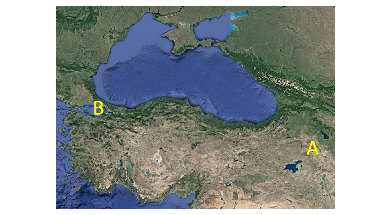
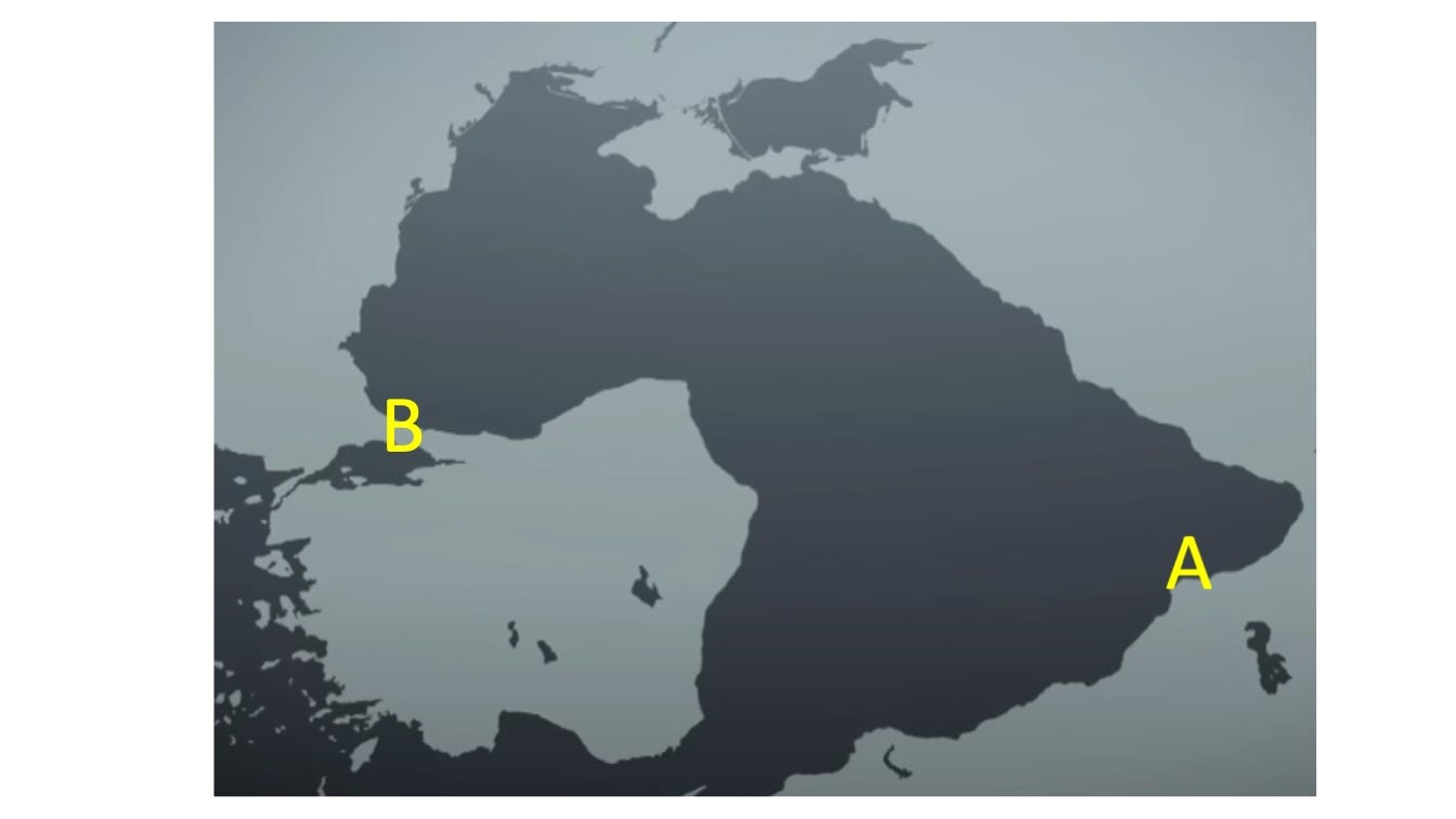
Their theory proposes that in 5600 BC (later revised by the authors to 6800 BC) the Mediterranean Sea catastrophically flooded the Black Sea via the Bosporus (B in the above pictures) and raised its water level by up to 100 meters. In essence, the authors claim the dark blue area of the Black Sea in the top picture expanded in a few months to include the lighter blue areas. The History Channel’s producers however tarted up their Black Sea Deluge with a bit of Hollywood magic (grey-shaded picture on the bottom picture). Their plucky deluge doesn’t take the wimpy route via the Bosporus, but heroically defies the laws of physics to climb 2000 meters above the Mediterranean Sea level to visit (Günaydın!) Turkey’s highest mountain, Mount Ararat (A), before hanging a left, and crossing numerous mountain ranges until finally reaching the Black Sea, completing an epic 1000 km journey over hill and dale. Might this tale be fancifully fictional, possibly fraudulently fallacious? If you believe this yarn then there isn’t a red pill strong enough, yet ever since my ad hoc rebuttal of the Human Extinction Theory (post 1) I feel an odd compulsion to explain the obvious to the uninformed, the clueless and the permanently confused alike. Apart from the facts that a) water generally prefers downhill flow, b) the two seas are currently connected via the Bosporus – a more prudent 25 km route, and c) the lack of any evidence of catastrophic flooding (erosion, strand lines, etc.) in southeastern Turkey, let alone near Mount Ararat, there simply isn’t enough water (vapour, liquid or ice) on or near Earth’s surface to raise sea levels by 100 meters above current sea level, let alone 2 km.
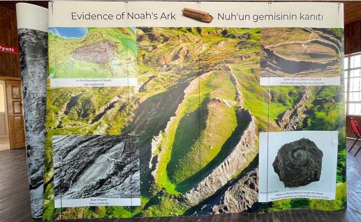
The local visitor’s center provides some more evidence this feature is truly The Ark:
The feature is located in the mountains of Ararat (the biblical Urartu)
Its size is about right: the bible claims 300 x 50 x 30 cubits (Gen: 6:15).
Metal and wood were found in the feature
Starting with the first one. Andrew Collins (who has an encyclopaedic knowledge of these things) mentioned that the landing location of Noah’s ark (apobaterion) was the theme of an early Christian turf war. Originally, Mount al-Judi (Cudi Dağı) near the Turkish-Syrian border was thought to be Noah’s apobaterion by the Syriacs, but the Armenians preferred a location closer to home, so they promoted johnny-come-lately Mount Ararat in the 11th century. The picture (upper left) demonstrates both mountains lie within Urartu, but there are a few reasons to give the nod to Judi. First, it is much lower (600 m) than Ararat (5100 m), so the Great Flood would have required significantly less magic water. Secondly, the bible states a dove returned to Noah with an olive leaf in its mouth (Gen: 8:11), and there are currently no olive groves near Ararat.
Point 2. A cubit is the distance from your elbow to the tip of your longest finger (!DON’T measure your cubit at work!), and can vary from 44 cm (Hebrew) to 52 cm (long Egyptian). The “ark” measures 150 m by 40 m. Close enough.
Concerning point 3, a Great Flood date of 6800 BC would place the Ark’s construction squarely within the Neolithic, before human use of smelted metals. And only a stone age moron would use metals to build his ark in the first place: metals are heavy and corrode in seawater, while wood is light and expands in water to make a nice water-tight ship.
So what is it? Geologists like to get up close and personal with the rocks to see what’s really what. From a distance, the feature is composed of a lozenge-shaped, steep-sided, dark-grey outer area (black vertically striped on the right), a yellow-greyish low-relief inner area, and a large limestone boulder or outcrop (blue area) poking through in the middle.

Turkish law forbids entering the “ark” so I couldn’t get as up close and personal to the limestone as I would have liked: Midnight Express 2 can be filmed with other volunteers like the felons (left photo) below.

The left zoomed-in picture shows the scale of the limestone. Its size suggests Noah likely wasn’t carrying it on his ark. A grim alternative is suggested by the fact that Noah liked to get drunk and pass out naked (Gen: 9). Did unicorns and giant sloths go extinct thanks to a Neolithic DUI? And wouldn’t that make a riveting clip on the History Channel?
Reason suggests that the hull of the ark (black outer area) should be made up of something that – you know - floats, so an up close and personal examination of the outer rim is just what the Dr ordered (right photo). The outer rim consists of pebble- to boulder-sized rock fragments (right photo: protruding in the center and upper right) embedded in a very dense clay-rich sediment. These sediments were unmistakably deposited by a debris flow. For those unfamiliar with the term:
When in motion, debris flows are similar to wet concrete in terms of consistency and density. They quickly rush down steep slopes, but stop, that is deposit their sediments, when the slope flattens or the flow loses speed. In the case of the “ark” feature a water-laden mix of clay, silt, sand, pebbles, boulders, etc. rushed down the valley. The flow lost speed when it collided with the limestone, then deposited a thick sediment layer downstream and to the side of it, as well as a “ponded” thinner, smaller deposit just upstream of the limestone (see overview photo). Because debris flows – once deposited - are difficult to erode under normal Turkish weather conditions the outer rim of the flow deposit remains in relief over the valley floor. For those blue-pillers who think the ark’s wooden hull may have contained the flow and later rotted away:
Mud flows are debris flows’ weak little sister. The video demonstrates that debris flows bulldoze almost everything in their path: houses, trees, bridges, wooden ark hulls, etc.
Unfortunately, this analysis hobbles the James Cameron production of “Critters of the Lost Ark” (“Based on a True Story!”), wherein a drunken and naked Noah (I’m thinking Russell Crowe) is raging and cursing so hard at the rain that he doesn’t hear Shem (a minor Baldwin) shouting “Limestone, right ahead!” and steers his ship into catastrophe. Darkness, a loud cracking noise, panicking animals tumbling into the dark waters, fade to a single, childless CGI unicorn dramatically shedding a single tear at the memory of her beloved departed “Pokey”. Fade to black & roll credits. The Oscar nominations would write themselves.
Should you visit Noah’s Ark National Park? Absolutely! The “ark” documents an interesting geological story, Mount Ararat is spectacular, and eastern Turkey is full of beautiful scenery, friendly people and great food. And it’s free! Just don’t go there expecting an ark.
References:
[1] Ryan, William B. F. et al., 1997, “An abrupt drowning of the Black Sea shelf.” Marine Geology, 138: 119-126.